Promthep Cape - The end of Phuket!
I guess it's the same wherever you live. There's always something new to explore close to home. Phuket is bigger than most people realise, the island covers over 500 square kilometers, plus it's only a short drive to reach places like Phang Nga, Khao Sok National Park, Krabi, or a 1 hour ferry over to Phi Phi. Doing this blog for the last 5 years has made me and the family get out and explore and really get to know our home. Hopefully it's clear from this blog that there is a lot more to Phuket than simply beaches, hotels and eating out.
Promthep Cape (or Laem Promthep - แหลมพรหมเทพ) is the name of the rocky headland than juts out into the sea at the far south west of Phuket. It's Phuket most southerly and southwesterly point, and many tourists and locals come here for views and to enjoy the sunset. There's lots of parking and a big open space on top of the hill with a shrine and a lighthouse. We've been many times before, it's a good stop off if you are touring the south of Phuket - you can visit Rawai beach or Naiharn beach, maybe the 3 Beaches Viewpoint, and Cape Promthep, it's all pretty close together and it's a very scenic part of Phuket with (as yet) little major tourist development. This is the "classic" view of Promthep Cape:
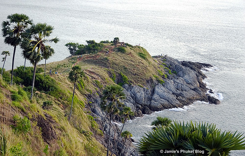
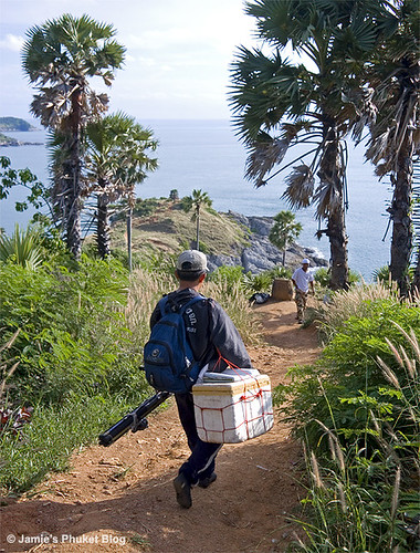
You can see that it's just bare rock lower down on the cape, this being due to the pounding that the most south westerly point of Phuket can get during the "Southwest Monsoon" season. Can be very rough around Promthep. You can also see from the photo above that people are walking downhill towards the end of the cape. There is a dirt path that leads from the road beneath the lighthouse. And amazingly, after more than 10 years in Phuket, I had never walked down that path, never seen Promthep Cape from below. We've been here many times of course, and my wife told me that she did walk down there a long time ago (before we met) and she thought it was a hard hike. So on a sunny Saturday afternoon, I decided now was the time to see something new. The path near the top is quite steep, rocky and slippery, since it's all loose dirt. The lighthouse is about 200 feet above sea level so that gives an idea of how far the path drops. I walked carefully down the steeper section. A fisherman carrying all his gear strode past...
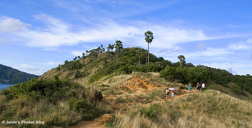
It flattens out after a couple of hundred meters and there's plenty of great views in all directions. First of all, a view I'd not seen before, looking back up to the top of Cape Promthep. Quite a number of people were walking down, but most stay at the top. By the time I walked up again there were hundreds of people waiting for the sunset. Down below it was much quieter...
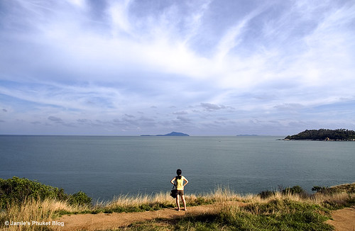
A girl stood in just the right place to model unknowingly, gazing out to sea looking south towards Racha Yai and Racha Noi islands, with the island of Koh Kaew Yai closer to the cape on the right. We've been out to Koh Kaew Yai before, getting a longtail boat from Rawai Beach.
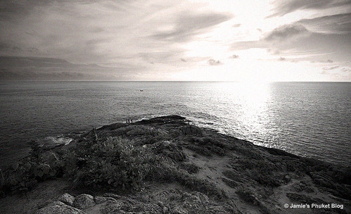
I did not walk right down to the rocks at the end of the cape, the path kind of disappeared near the end and I did not fancy too much rock scrambling, though plenty of people were doing it. I just found a rock to sit on, enjoying the sun and the view. This is the "end of Phuket" ...
The walk back up was not too hard really. Other people were still heading down including a party of Muslim schoolgirls from Yala who wanted to take photos with the
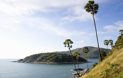
(above) View looking North while on the path down Promthep Cape - the island is called Koh Mun, it's just 200m away from the mainland, but as far as I know it's totally uninhabited. If you follow the coast north from Koh Mun you have Yanui beach and then Naiharn Beach.
There's a lot more to see in this part of Phuket which has not really been blogged yet. I have not been to Naiharn beach for ages and have always meant to visit Naiharn temple too. Nearby is little Yanui beach which I did blog back in 2006 but it needs revisiting. Rawai beach is good for a seafood lunch, and (unless it's low tide) you can get boats out to offshore islands. I do mean to get out to Koh Bon sometime soon, it's less than 2km from Rawai. Always more to explore. Always more to Phuket than meets the eye!
Google Map - Cape Phromthep Area
View Phromthep Cape, Phuket in a larger map
You have been reading : Promthep Cape - The end of Phuket!
Looking For More? Search Jamie's Phuket Blog ...
Find Your Phuket Hotel ...
